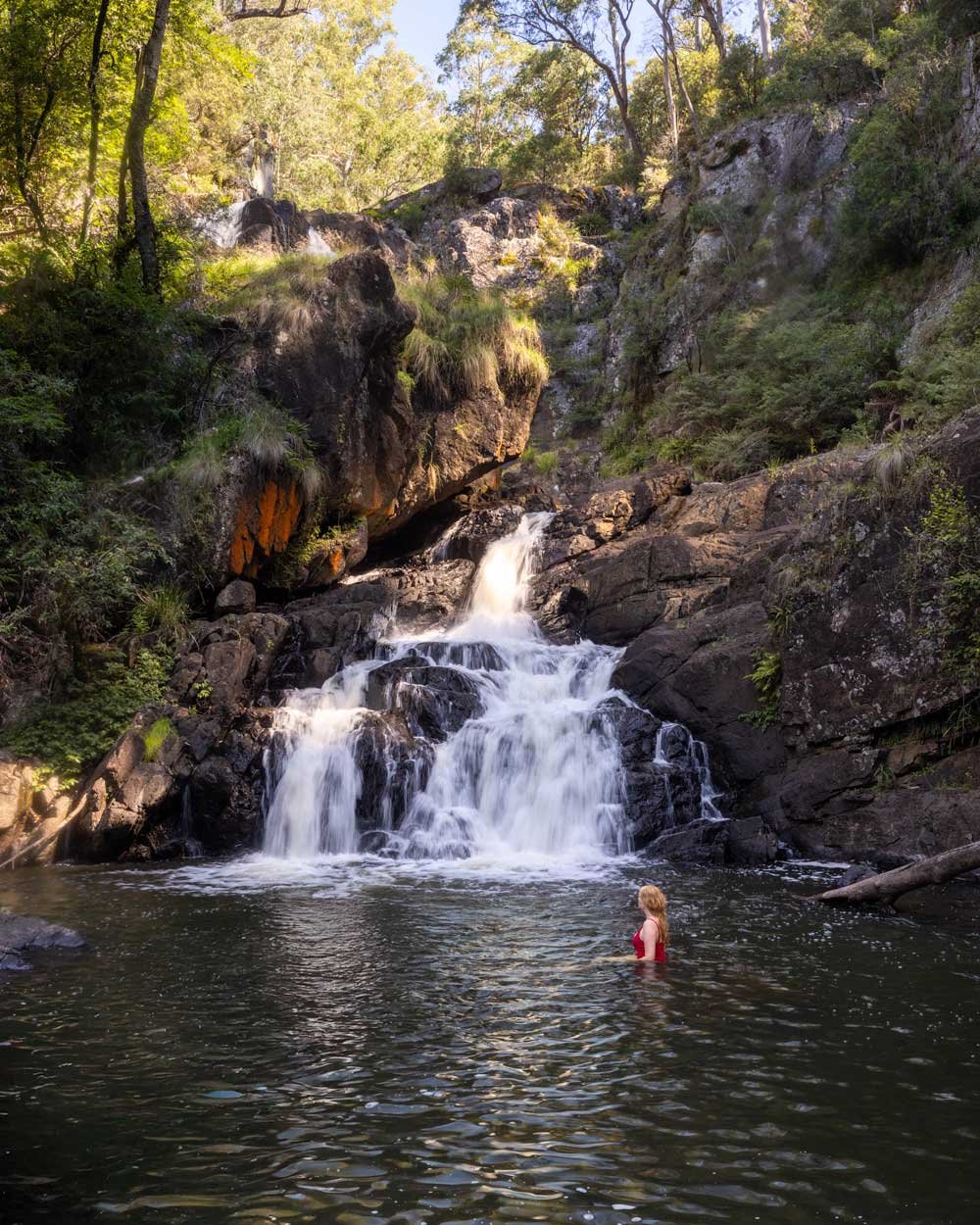
This is the wild side of Barrington Tops that few people ever get to see. A spectacular 23m waterfall that plunges over a cliff face and there won’t be another soul around to witness it besides you. Visit in the middle of a sunny day and you’ll find a vivid rainbow shimmering in the spray. The waterfall is so captivating you’ll be wracking your brain as to how there is no walking trail to reach it.
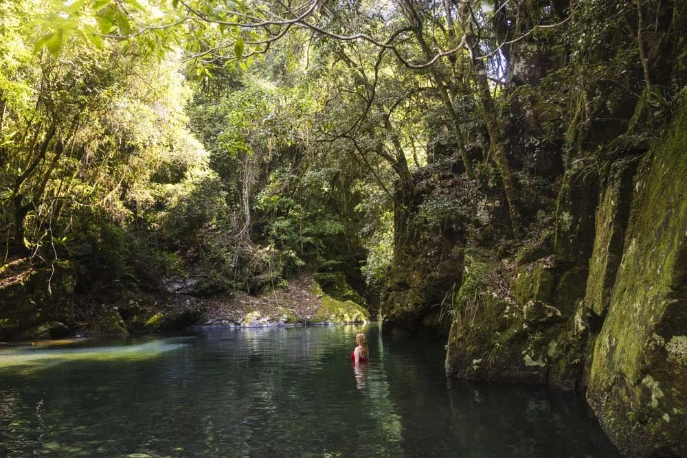
There is a second grotto waterfall below, with a large swimming hole surrounded by sculpted rock walls and dense bush. You can swim here on the hottest of summer days and feel confident that you will have it all to yourself.
However, there’s a catch. Though the walk to both spots is very short, it’s rough and overgrown. It won’t be for everyone, but if you think it might be for you, read on.

The walk to Rainbow Falls
The stats
Distance: 1.5km return (including the second waterfall)
Elevation gain: 140m
Difficulty: A rough bush bash
Trailhead: Cascade Falls Campground
Summary: Don’t be fooled by the stats and the short distance of the track; it’s rough, slow going and remote and we wouldn’t hike here without a PLB. There is no phone signal in this area and if you did run into difficulties, it is too seldom visited to rely on help from somebody else.
There are two ways you could access the top of the falls: the first is by rock hopping downstream from the parking area. The second is the route we took, following an overgrown dirt track, which is steep, overgrown and eroded in places. I think I’d try the creek next time!
Reaching the best view of the falls will require a short but steep scramble and this has some loose soil, making it quite slippery. It’s also very overgrown.
Reaching the second grotto waterfall is considerably easier, with a less steep, but still somewhat loose descent.

Starting the trail
We can only describe the route we took, which was to stick to the bush. However, you may want to consider the creek if you don’t like the look of the bush ‘track’.
The key to this walk is to know that the waterfall is downstream (east) from the campsite and the easiest route to reach it is to keep parallel to the creek on the southern bank.
To find the ‘track’ walk to the south eastern side of the campsite and head east (i.e the part of the campsite that is furthest from the creek and look for a trail that heads into the bush).


At first there is a somewhat obvious worn dirt path through the bush. It’s narrow and has some fallen trees to negotiate, but it’s flat and not near any kind of drop.
Don’t stop too long on this first stretch as it does have a healthy leech population. Check yourself when you get to the falls. We got a couple, but were able to flick them off before they bit!

You’ll follow this worn track for a couple of hundred metres and this section is easy.
The rough track
After this the path significantly narrows and there’s not always an obvious track to follow. However, if in doubt, stay about 20-30m away from the creek. The area above the tree ferns seemed to be the easiest area to walk along.

You will begin traversing a dirt path along the side of a relatively steep drop to the creek below. I took this section very slowly and carefully, the footing is good, but the narrow track beside the drop had me very cautious.
Luckily it isn’t too long before the bank becomes far less steep and the feeling of exposure disappears. It can be hard to follow the track here though as it’s not really a path.
The trick is to stay relatively high for a couple of hundred metres, still a good 50m below the road, but don’t be tempted to get too close to the creek bank, where footing is more unstable.
Everyone will walk this section slightly differently. Joe did this track four times and each time took a slightly different line.

Roughly 400m beyond the campground you will begin heading downhill and this is quite easy at first, with any short loose bits being surrounded by trees for stability if required.
You will then begin traversing right and again this is not too bad, you just need to watch for overgrown scratchy sections and any plants that may get tangled around your feet.
Once you’re at creek level, you will hopefully see a worn trail that heads up the rocks. There is a very minor amount of climbing up rocks, but there is a worn path you can follow at this point.
The trail uphill is very short, but requires clambering under a fallen tree and then the path begins to get rougher.


Just beyond this is where I had a very unfortunate incident.
I’ve lost count of how many hikes we’ve done in Australia now, but it would be above 500. I guess there’s a first time for everything and I accidentally disturbed a bull ants nest.
A quick google search is all you need to know about what happens if they feel their nest is threatened and the stings from the ants were enough to produce a banshee shriek of horror!
I know it’s unlikely this will happen to anyone else, but I couldn’t write about this walk and not mention it just incase; may Lady Luck be in your favour!
The scramble
Roughly 500m from the campground the roughest part of the track begins. You will need to steeply descend towards the falls on a loose overgrown track.
The photos don’t really show how much contorting through treefall and loose ground you will have to negotiate.

It’s rocky in parts, but a decent amount is on loose soil which can be slippery. It’s very overgrown around here, requiring care not to get tangled up or scratched.
You are also not exactly by an exposed drop, but high on a bank where a slip could be very problematic.
There are often trees to use for stability and I made full use of every one. Partway down there is a somewhat awkward log to climb under and from here you’re 130m from the best view of the falls.

The rest of the descent is similar and had a lot of loose soil, but does feel far less exposed. You will pop out of the bush and onto a large rock platform with a stupendous view of the falls.
Rainbow Falls
The waterfall is absolutely stunning, it’s crazy to think there is a viewing platform for Gloucester Falls, but nothing for this 23m cliffside beauty. In fact, this waterfall technically has no name on any map we have found.

We’ve named it Rainbow Falls for the purpose of this blog and because I can’t refer to somewhere this special as the waterfall with no name.
The falls do cascade into a small swimming hole at the base. However, the scramble down looked a little tricky and though I would have normally given it a go, following the aforementioned bull ant fiasco, I did not think it would be wise.

As I didn’t try I can’t say for sure if it is possible, but no doubt a more adept scrambler than me would manage it : )
The lower grotto falls
The base of the lower falls is 100m away from the viewing area for Rainbow Falls. Bear right through the long grass and then you’ll come to a little bit of bush.
Traverse a little here and then begin descending towards the creek, keeping slightly right to avoid the drop on the left, which was too high to get down.

There are a few steps of loose soil, but the path is not too difficult or steep when following the route on the right. There are a few rocks to climb down and then you will arrive at the stony river bank and base of the falls.


The waterfall is surrounded by rock walls, ferns and dense bush, so it has a grotto like feel. The waterfall was really powerful on our visit which gave it a much wilder vibe than if it were a dainty cascade.
There’s a large swimming hole at the base, but there are boulders inside the pool. You can swim, but it is restricted to certain sections to avoid the rocks.
The current was relatively strong on our visit, but there was room to swim outside of it easily enough.
Getting into the pool is fairly easy, but there are a few small rocks and stones to walk over before it’s deep enough to swim and these are uncomfortable underfoot.

When you’re ready to leave the pool you retrace your steps back the same way, knowing that you will likely go a slightly different route back.
The footing felt easier to me going uphill as I was less concerned about slipping, though still tread carefully on that 200m stretch of particularly rough track.

Keep them wild
Please remember to take all rubbish with you and keep these places wild and pristine - as with anywhere in the outdoors. It’s important to leave them exactly as you found them so they will remain beautiful for generations to come.
Litter tends to breed litter, so if you do spot any and are able to pick it up and dispose of it outside the reserve, it will go a long way to keeping the area clean.
Accessing Rainbow Falls and the Cascades Falls Campground
The trail begins at the Cascade Falls Campground in Barrington Tops State Conservation Area. The campground is lovely and remote, but very basic - there are no toilets, it’s basically just a clearing. It’s right beside the river and a set of cascades which makes it quite soothing.
The last 2.4km of the official road to the campground are marked as 4WD only. It’s a narrowish dirt track and has a couple of short somewhat steep bits. This is the access road known as the Wombat Track on the southern side.

However, if you don’t have a 4WD you could get to within 1.3km of the campground by heading to the northern side. From here you could walk the rest of the road. There’s a very shallow creek crossing just before you reach the campground. This would allow you to access the track to the falls without a 4WD.
As with most of Barrington Tops there is a long stretch of gravel road before you reach either of these access points to the campground, but they are generally kept in very good condition and suitable for any vehicle during dry weather.
The closest town to the campground is Gloucester and this is around a 66km (1 hr 15 mins) drive away.
This post may contain affiliate links, meaning at no additional cost to you, that we will earn a small commission if you click through and decide to make a purchase. This helps towards the costs of running our website. Thanks for your support.