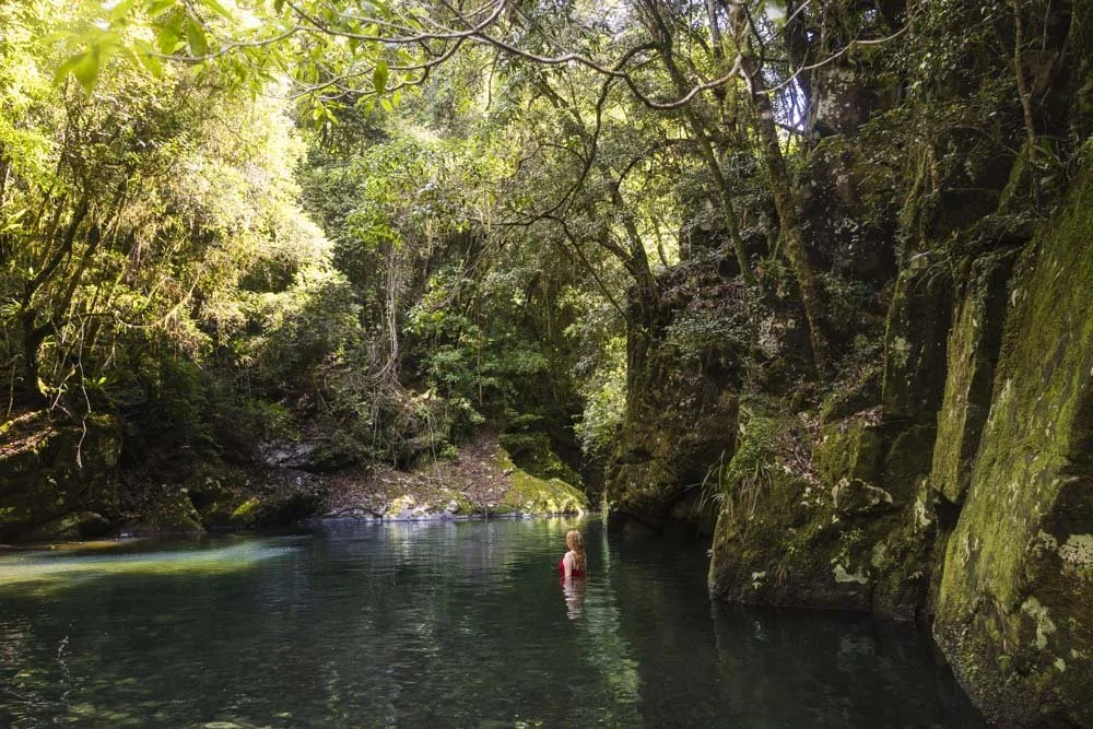
Whilst most people speed past Sharpes Creek on their way to the more well known Gloucester Tops Circuit, a stop here is definitely worth your time. You don’t have to do the full circuit walk to experience a little of the magic the creek has to offer. Simply walking for a few hundred metres through the jungly forest will bring you to the most beautiful turquoise blue creek. The colour is almost glacial and such a surprise to find here in Barrington Tops.
If you’re staying in the campground nearby, then it’s worth heading back in the evening when you’ll find a little night time surprise!

The Sharpes Creek Track
Distance: 2.8km return, or 4.5km loop
Elevation gain: 185m (full loop)
Difficulty: Easy - moderate
Trailhead: Layby at Gloucester River Campground
Summary: You can walk the Sharpes Creek Track in one of two ways: a 2.8km return walk, which is all through rainforest, or a longer 4.5km loop track which includes a significant amount of walking on the road - albeit a beautiful dirt road lined with rainforest.
The loop track has a steep hill to climb, whereas the shorter return walk doesn’t have much in the way of elevation gain.
Both versions of the walk include three minor creek crossings
Gympie gympie warning
Please note that the Gympie-gympie (giant stinging tree) can be found along this track. We saw it several times away from the main path, but there is one point where it does grow very close to the trail - we’ve marked where in the track notes below.
The sting of the leaves of this tree are no joke; do a quick google search to familiarise yourself with what it looks like, but don’t be overly worried as when you know what to look for they are very easy to avoid.


Starting the trail: through the rainforest
From the lay-by close to the Gloucester River campground (you can find it here on Google Maps) take the trail on the opposite side of the road and head up a couple of steps and into the forest.
It’s dense and jungly straight from the off and you can hear, though not yet really see, the creek.

There’s a tiny uphill section before the path flattens and though it’s a maintained trail, it’s a little uneven underfoot.
There’s also one obstruction currently on the path (though it may be cleared) where you have to climb through a tree and some vines - though it’s not difficult.

After 350m you’ll come to the first creek crossing and this is where you’ll see that incredible turquoise water.
We couldn’t believe how beautiful it was, just like the water colour at the Promised Land in Bellingen, yet we’ve never heard anyone mention it before!


Though the water is not deep enough for swimming, you can definitely have a paddle and the surrounding dense rainforest makes it all the more atmospheric.
The creek crossings
The first creek crossing has rocks to use as stepping stones, and as with all the crossings, would normally be very shallow. We were walking after some significant rainfall and some of the rocks were submerged.
We could still cross but there were less rocks to choose from. It wasn’t hard, but did require a little more care than usual.


The second crossing is 100m later and the third is 70m after that, all are similar and the only thing to really watch out for is that the rocks might be a touch slippery, and the odd one wobbles a bit.

This first 520m of the walk (up to crossing three) is the most beautiful, as you have both the rainforest and the turquoise creek.
After this point, you still have some more stunning forest, but you’re relatively high above the creek and then head away from it entirely. So if you only want to do a short walk, you could turn here.

Continuing through the rainforest
After the third creek crossing, the path continues uphill, but it all but flattens out again 180m later. Over the next 700m the path will undulate, sometimes steeply, but each hill, whether up or down, is always very short.

The scenery is gorgeous, with so many hanging vines, epiphytes and strings of moss dangling from skinny branches. If you’re walking after rain there will no doubt be plenty of colourful fungi too.


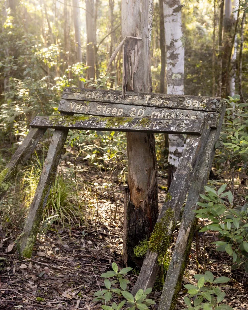
At the 1.4km mark you’ll reach a signpost and this is where you need to turn around if you want to avoid the steep hill.
We saw the sign warning of the steep hill and thought it was probably an exaggeration, but the joke was on us because it really was steep!
It isn’t at all slippery when heading uphill, but I wouldn’t have liked to walk down it. In terms of scenery, you’ve reached the end of the rainforest here and will head up into dry eucalypt forest.
The climb and finishing the track
If you choose to continue the loop, then the next 700m are steep. The path is good, but it’s a sharp incline. Near the top of the climb you’ll get some nice views out over the rainforest to your left.


Roughly 650m after the signpost there is a large amount of Gympie gympie trees which are right beside the track.
Up to this point we only saw them just off the track, but here they are on either side and above the path, creating an arch.
We called it the ‘Gympie-gympie gauntlet’. You can walk through easily, but this wouldn’t be a place to wander mindlessly or you might get a nasty surprise!

Roughly 50m later the path will flatten and you’ll reach the road a further 100m after that.
Though I am never normally a fan of road walking, I have to say this one was actually enjoyable. We didn’t encounter any cars, the descent was easy and the surrounding forest, spectacular.

There was a huge amount of birdlife and it turned out to be a lovely end to the walk. Roughly 1.7km into the road section you can make a left to finish the trail on the Gloucester River Track, which is signposted.

It’s just a few hundred metres of flat forest path before you reach the first campground and then continue through to the main campsite and back to your car just beyond.

Sharpes Creek by night
If you’re staying nearby and you fancy a little nighttime adventure, then you can head a little way along the Sharpes Creek track to find the secret glow worm colony. Now granted it’s not huge, just a couple of hundred spread out along the trail on our visit in winter (numbers tend to be higher in summer), but it’s still a magical sight and you won’t have to share it with anyone else!

The glow worms begin around 100m into the track, but the numbers are very sparse, just a couple here and there. However, when you get 300m in, close to the creek, there were over a hundred in a relatively small area.
They run along the lower wall on the right of the path and many hide in the ferns! You need to let your eyes adjust to really take them in, at first they will appear dim. The longer you stay with zero torch light the more you will see.

We also saw some shining on the opposite bank, but as the creek was up we didn’t want to cross in the dark. There may well be more further along the track too, though we can’t be sure.
The dell is not on the scale of many in the Blue Mountains, but the walk is short and it’s always special to visit these hidden spots that you don’t have to share with anyone else.
Tips for visiting the glow worms
It is best to wait until it’s properly dark before you go looking for glow worms. You can see some in the twilight, but nowhere near as many. Leave it at least one hour until after sunset for the best results.
To really see all the glow worms that are there, you need to turn off all lights, and let your eyes adjust for at least five minutes. However, the longer you allow, the more you will see. Often we get to an area and can’t see that many, only to see more and more appearing before our eyes like magic!
Caring for the glow worms
Please protect this colony when you visit.
Please don’t shine light on the glow worms, they don’t like it and will turn their lights out. You’ll see so much less if you keep a light on anyway.
Also if you’re keen on getting a photo, bring a tripod which will allow you to capture the glow worms without shining a light on them. None of our photos use any artificial light. Here are some tips for photographing them.
Getting to Sharpes Creek
The Sharpes Creek Track begins beside the Gloucester River Campground in Barrington Tops National Park. The last 11.5km of the road are gravel, but well graded and generally suitable for any car (though they can deteriorate after bad weather). There are six fords to cross which are shallow unless there has been heavy recent rainfall.
It’s roughly a 45 minute (38km) drive from the nearest town of Gloucester.
This post may contain affiliate links, meaning at no additional cost to you, that we will earn a small commission if you click through and decide to make a purchase. This helps towards the costs of running our website. Thanks for your support.