Whilst the easy walking track that once led to Wombeyan Waterfall no longer exists, those who are willing to go off track will still reach this stunning spot, and the lack of formed path means it’s highly unlikely you’ll see anybody else!
The two tiered waterfall is stunning after rain and there’s enough room for a waterfall shower beneath both cascades. The top one in particular is a very picturesque spot for a dip.
Reaching the waterfall involves a fair amount of rock hopping and negotiating uneven terrain, but it’s not overly strenuous.
Here’s everything you need to know to visit Wombeyan Waterfall.

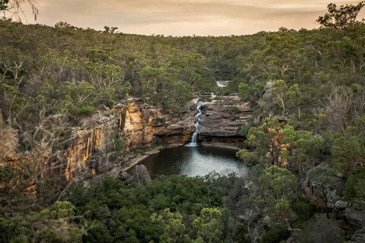
The Wombeyan Waterfall Circuit
The stats
Distance: 4.3km circuit
Elevation gain: 160m
Difficulty: Moderate due to the terrain
Trailhead: Waterfall Track, Wombeyan Caves
Summary: There are two ways of accessing the waterfall and though one route is shorter than the other, we still recommend the circuit option. That’s because the shortest route requires negotiating 50m of steep terrain that would be quite dodgy as a descent route.
When ascending you are far less likely to slip. I personally would not recommend approaching the waterfall via the shortest track, but I was happy with it as an exit route.
Assuming you want to walk the circuit, you’ll start on an easy grassy path, but it quickly becomes a little overgrown, though still easy to follow. When you reach the creek there is plenty of debris and you’ll need to rock hop and crisscross the creek many times looking for the easiest route upstream.
After a time, I decided simply walking through the water directly was easier than rock hopping and using the debris strewn riverbanks. The last few metres to the base of the waterfall involves a bit more rock hopping.
The exit route has the 50m steep climb up a riverbank to negotiate, but after that it is a lot easier. It’s still overgrown in parts and has some significant debris, but much of it is on an eroded fire trail. There is always room to walk a safe distance from the fire trail gullies.
Starting the trail: the easy beginning
From the campground car park, the walk begins along the grass, heading north, beside the shady trees and usually a fair number of kangaroos!
You can stick quite closely to the creek, occasionally diverging slightly left to move around debris.

After 320m you will see the Wombeyan Waterfall Walk signpost and follow it right, gently uphill. The path is obvious at the beginning and will level out after 200m.

Just before this you’ll see a fence and you want to keep parallel to it. The path now narrows and becomes a lot bushier. It’s overgrown, but not horribly so if you’re used to off track walking.
At the 670m mark there’s a fork and you want to head left. From here the track will become more indistinct.

Following the creek upstream
You now want to head down towards the creek at the easiest point you can see. We continued for a further 130m from the fork and then cut down easily enough.
From here you cannot go wrong directions-wise, you are simply following the creek upstream all the way to the waterfall.


Our watch measured this distance to be 1.2km, however, we crisscrossed so many times that it will be shorter in reality as tracking is never highly accurate on this kind of terrain.
Joe decided to keep dry boots and chose to use the rocks and riverbanks to reach the waterfall. I tried this for a while before deciding it was too tedious and succumbed to wet boots for an easier ride.

There is plenty of debris along the creek, some of which needs to be climbed through or around, even if you are walking through the water.
Watch for slippery rocks as always, but in general, they were actually quite grippy, even when wet.
The creek is very pretty with many cascades and small pools (too small for swimming). None of the cascades require scrambling up, there’s actually no scrambling on this route, the closest would be climbing over fallen trees.

Just under a kilometre into the creek walk, there’s suddenly a decent 100m long stretch of easy walking on the riverbank on the left side of the water and I remember marvelling at how quick it felt after schlepping through the water!

As you re-enter the creek 100m later, you are now just 200m from the waterfall and you should be able to hear it.
The last little bit to the small pool at the base of the falls is more easily done on the riverbank, as the rocks in the creek become boulders.
You’ll arrive at the base of the lower falls 2.05km into the walk - or likely less as we went back and forth so much!
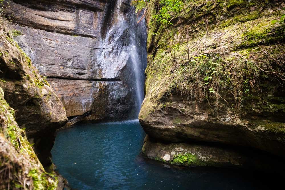
Wombeyan Waterfall
The waterfall has two tiers, with the top one being the most picturesque. The surrounding limestone walls and wedged boulder makes the waterfall feel more dramatic. It’s best visited after some decent rainfall to ensure it’s flowing nicely.
Both the upper and lower falls have small pools, none deep or large enough to swim, but good for a waterfall shower and plunge. My favourite is the upper falls, which is larger and more beautiful.

It’s also tucked away from sight behind the large boulder, so it feels incredibly secluded. The water is relatively cold, even in summer, but perfect for cooling off on a warm day.
Watch out for the those little fish that like to nibble dead skin though as there were a surprising number!

In terms of accessing the upper falls, you need to climb up the riverbank on the left side, which avoids any potentially slippery rock scrambling on the right side.


This is a short but steep few metres which can be slippery when wet. Tread carefully as you climb and then there’a a very short flat section to the falls, the whole distance from the lower falls pool is around 70m. Take care to stay back from any edges.

Getting into the pool itself is easy as it’s set back from the edge and you can step off the small rocks beside the falls and into the relatively shallow pool. The water is cool and a pretty shade of green, and looking up at the falls and gum trees is fabulous.
There’s even a tree which has its roots wedged into the cliff wall beside the waterfall. It’s a gorgeous spot and though I do always prefer pools you can actually swim in, having a plunge here was very special.
There’s a similar small pool beneath the lower falls, but I didn’t enjoy this one very much, as it was full of slippery rocks and moving around the pool felt like a major slip risk. This was not the case for the upper pool.

Keep them wild
Please remember to take all rubbish with you and keep these places wild and pristine - as with anywhere in the outdoors. It’s important to leave them exactly as you found them so they will remain beautiful for generations to come.
Litter tends to breed litter, so if you do spot any and are able to pick it up and dispose of it outside the national park, it will go a long way to keeping the area clean.
Heading uphill
If you don’t like the idea of the initial steep climb without a path, you can retrace your steps back the same way.
Otherwise you start climbing up where you would take the path to the upper falls pool, but instead of veering right to the falls, continue straight up.

There is no set track and it’s steep, so do take care and don’t go when the ground is wet or it will become slippery.
This steep section is around 50m before it slackens off and becomes much easier, you’ll also pick up a worn path.

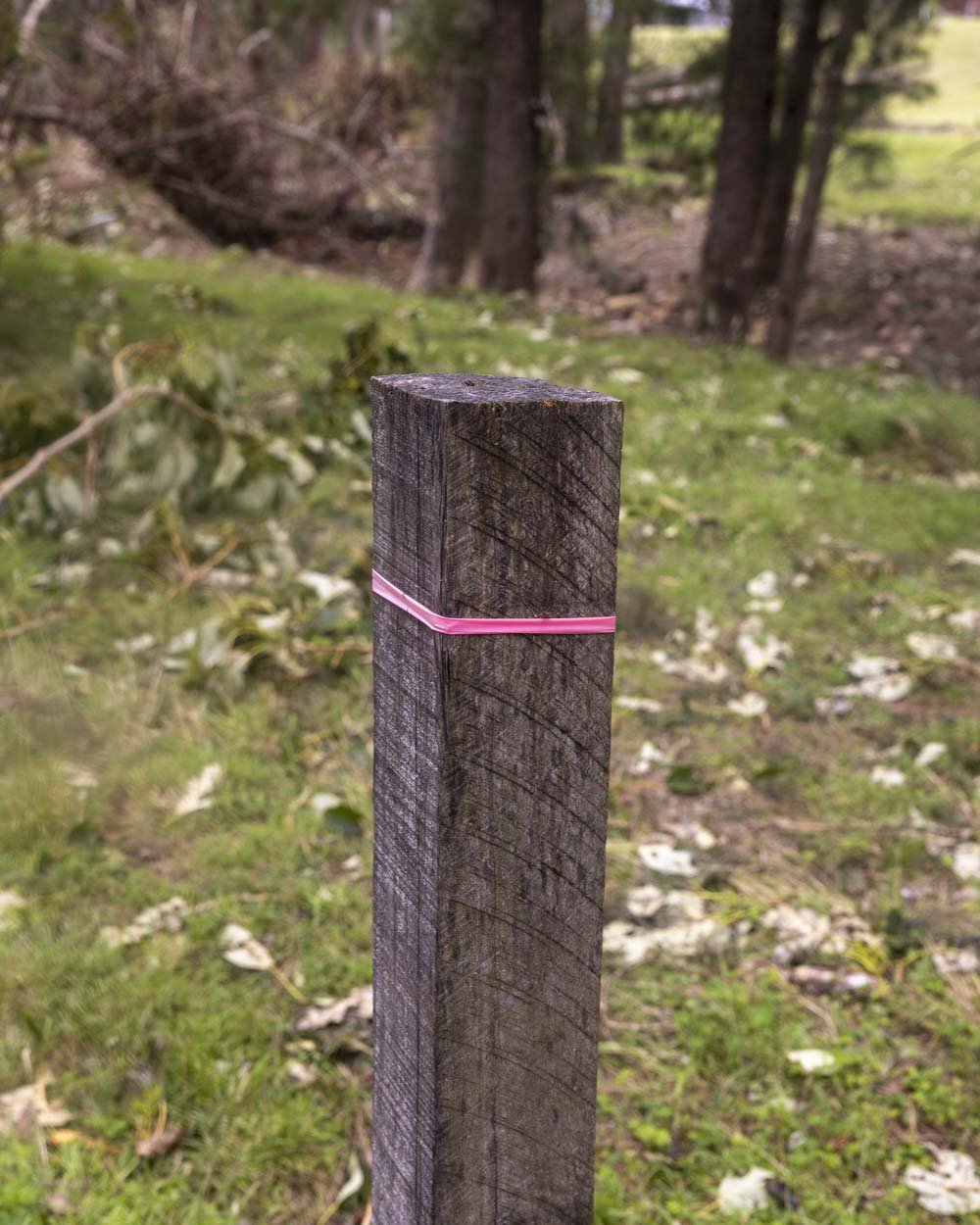
This path is narrow, but has some bushiness to it and does not feel exposed. After around 60ish metres you will see a pole sticking out of the ground on the right.
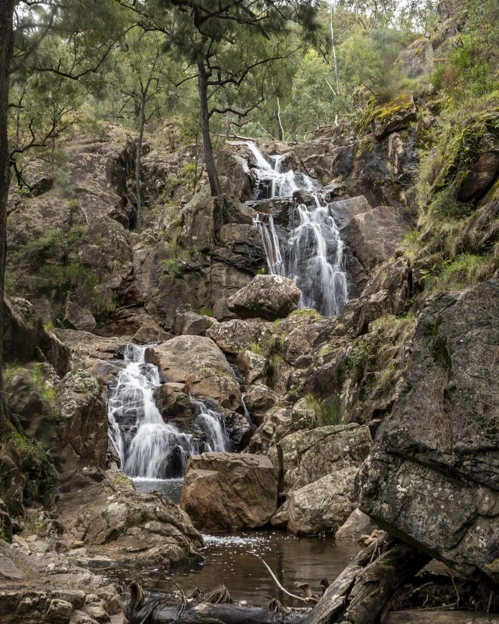
You can follow this worn path downhill for 20m and it will lead to another small waterfall pool.

This was very pretty, with deep green water. Again it’s just a plunge pool, but it’s a lovely one. Around 90m above this pool is what looks like a dam.
If you go and check it out you still need to come back down and onto the main path again.


Completing the circuit
Once you’re back on the worn path there’s a bit of tree fall to negotiate and then you’ll arrive at what feels like an old fire trail (30m later).
This is flat, blissfully easy to follow and quite open for 220m before it narrows to a more overgrown bush track, but only for 80m.

You then need to head downhill to the right and will come to what feels like an old turning circle. It bends left here. The path can be overgrown along the next stretch, but it’s not too bad and it’s easy enough to follow.

The eroded gullies begin 290m after the trail bends left.
Remember to steer well clear of the gully edges which may be unstable. The path is now generally quite wide and decent progress can be made.

When the path flattens you’ll also start to see a few pink ribbons around which were not present anywhere else on the track.
The one to watch for is 500m after the turning circle, the path will have flattened and the ribbon marks making a right turn, away from the eroded gully and into the bush. You’ll then follow this worn path back to the grassy area where you started the walk, passing the Wombeyan Waterfall Walk sign again.
Getting to the Wombeyan Waterfall Walk
The Wombeyan Waterfall Walk is located in the Wombeyan Karst Conservation Reserve in the Southern Highlands. The reserve has been hit by many flooding and storm events in recent years, so check it’s open here before making the journey out.
There is visitor parking by the toilet block before the gate and road which would take you towards the caves.
Though two roads lead to the reserve, only one is currently open and that is via Taralga. A section of gravel road begins 14km before you reach the reserve, but it doesn’t last the whole way to the parking area. Currently 8.5km of the road is gravel and the rest is sealed. It is suitable for any car at time of writing.
The walk is no longer signposted, so you need to follow the directions above.
This post may contain affiliate links, meaning at no additional cost to you, that we will earn a small commission if you click through and decide to make a purchase. This helps towards the costs of running our website. Thanks for your support.