

It’s not often a brand new walking track opens in NSW and this one is a real delight. The Lost City Track takes you through some of the most incredible pagoda scenery that the mountains have to offer and all on a well formed track.
We’re used to scenery in this area being enjoyed between gaps in the thick scrub, so to have a proper walking track offering dramatic views without the hardship is a treat. And it doesn’t mean that you can’t make your own adventure if you like things a little less tame, there are endless pagodas to climb with spectacular views at every turn.
Here’s what to expect from the Lost City Track and why it’s not to be missed.

The Lost City Track
The stats
Distance: 6.2km circuit
Elevation gain: 270m
Difficulty: Easy, but not flat
Trailhead: Lost City South Lookout
Summary: There are two tracks at the Lost City which can be used to form a partial circuit. We recommend starting with the Lost City Walking Track and finishing with the Miners Track.
The Lost City Walking Track has the best scenery and the gentlest incline, meaning you will descend on a shallower track. The Miners Track is shorter and steeper and therefore better for ascending.
Whichever route you take there are quite a few stairs to negotiate, though the path is generally excellent. There is one steep metre or so on the Miners Track where steps have been carved into the rock, but there is a rail here for stability if needed.
Starting the trail: to Lost City Lookout
From the Lost City south car park, the walk begins on a wide fire trail heading ever so gently downhill. You will arrive at the Lost City Lookout 390m later.


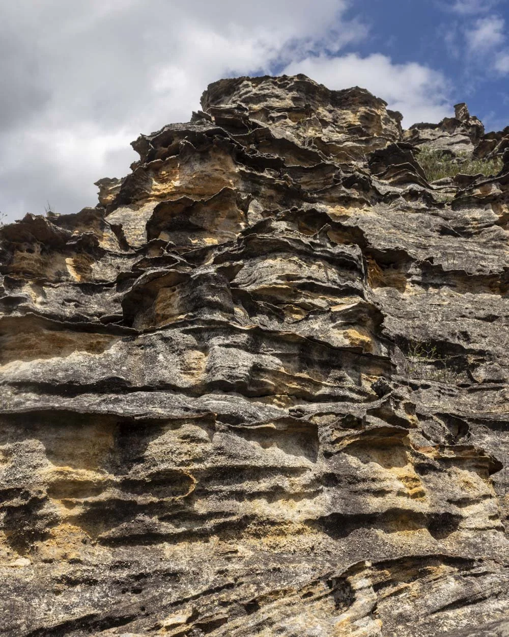
The view is panoramic and simply stunning, with endless cliffs and pagodas as far as the eye can see. Though there is still a little bush generation work going on in the foreground, it doesn’t detract too much from the fabulous vista.
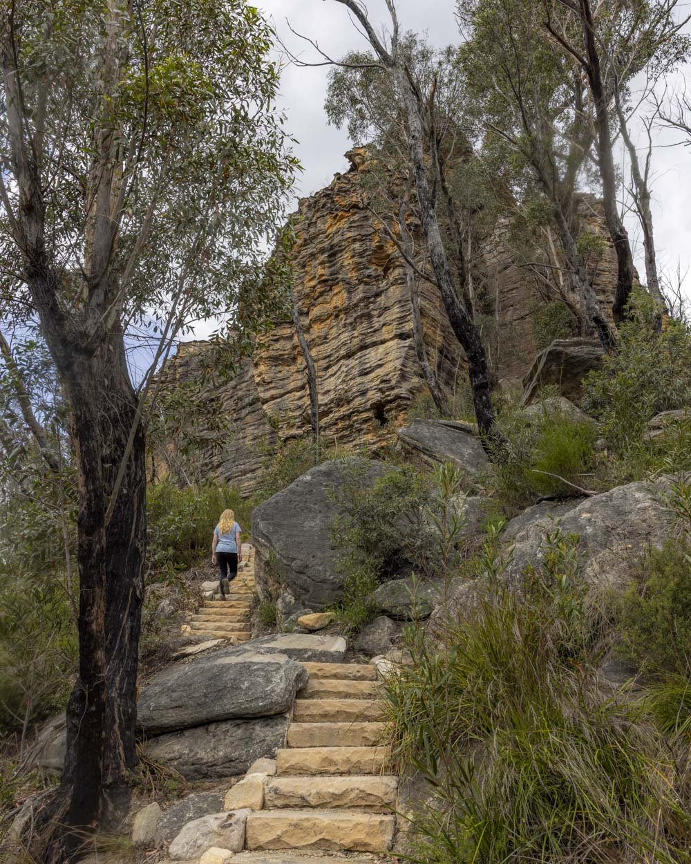
From the lookout you’ll begin descending on a series of stone stairs. There are a few rocky sections between the stairs, but nothing challenging.

Through the pagodas
You will reach the junction between the Lost City Walking Track and the Miners Track 630m from the car park (just under 250m from the lookout).
From here we recommend heading right, following the Lost City Walking Track.


Roughly 140m beyond the junction you’ll come to an unofficial viewpoint to the left of the main track, beside a very impressive pagoda.

You feel very close to the rugged peaks and rocky outcrops here and it’s well worth the short diversion. You can also climb the pagoda, which is very easy, with excellent tiered rock allowing straightforward access to the top - just make sure you never put any weight on the flakes which could be weaker and more likely to break off.

The main path continues to the right of the pagoda and you’ll have a short (200m) stretch of flat track with lovely views. At this point you will continue the descent on very atmospheric stone steps.

The stairs have been built to blend in with the natural environment and the parks service have done a wonderful job at creating a great path that doesn’t spoil the aesthetics of the natural environment.
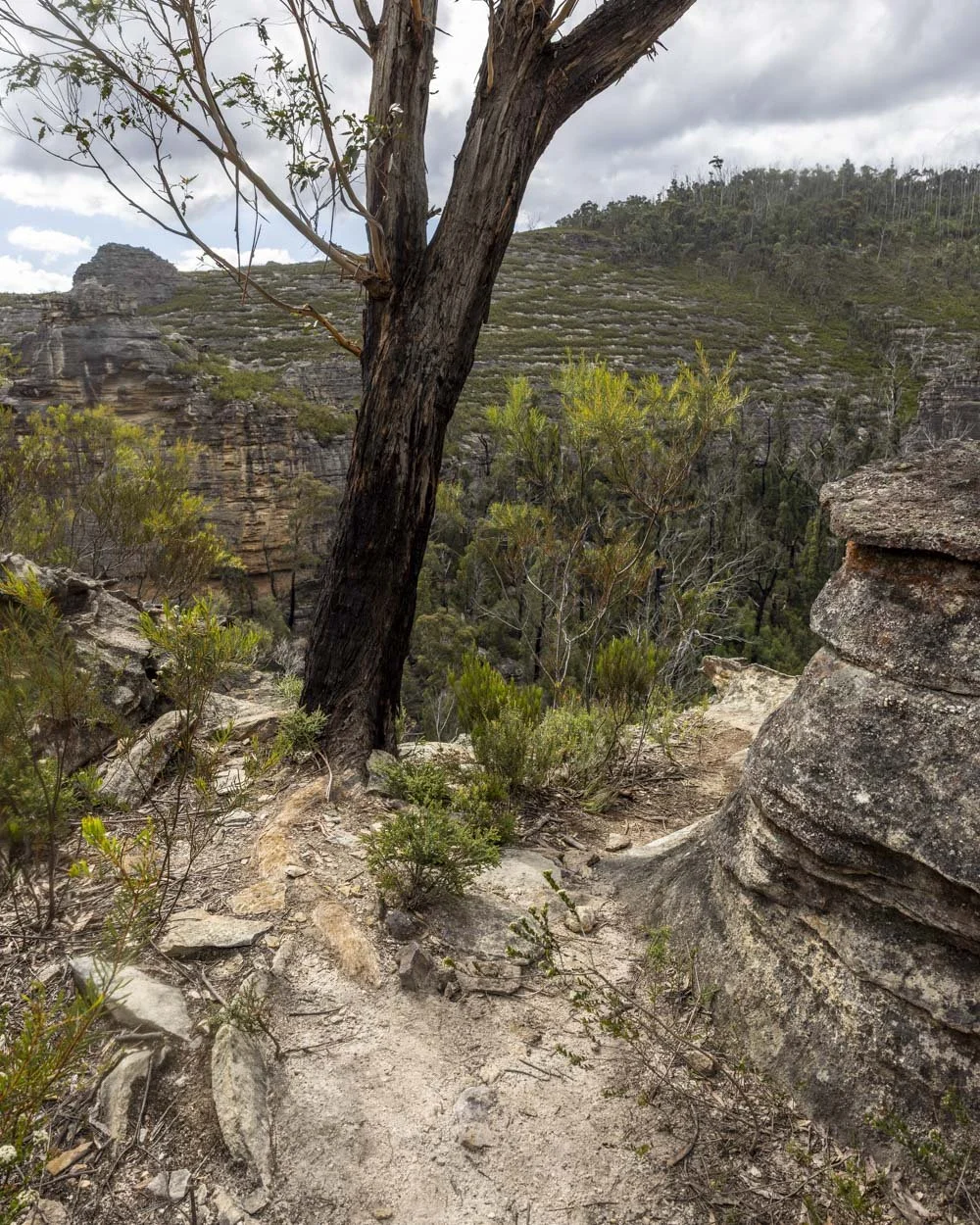
After 250m heading downhill the path will flatten and then gently undulate.

The scenery is outstanding, with soaring cliffs above you and dense bush surrounding you, retaining much of the wild feel the Gardens of Stone is known for.
One of the rocks along this stretch reminded me of Thor Hammer on the Asgard Swamp Walk, though it definitely couldn’t be climbed by hikers!

Towards the lookout
The walk continues in a leisurely fashion for the next 400m and you will then reach a short section along a rock platform. There’s a very minor descent here, but there are rails and it’s by no means difficult.
You will also be able to see a dam to the right which was built in the 1920’s to provide water to the nearby town of Lithgow (no swimming allowed).

You’ll cross the creek several times on smooth level stepping stones and pass a few relics of the mining era (sadly, there’s also an asbestos present sign here).
Just over 2.1km into the walk you’ll reach a junction and this is where the Lost City Walking Track and the Miners Track converge. Both trails now continue right, towards the Lost City North Lookout.


The next 650m are flat as you head towards the dam wall. At the dam the walk heads uphill for 320m with a few little flat bits inbetween and some good views.
The Lost City North Lookout
Approximately 320m after you begin climbing uphill beside the dam you should look for the worn path leading left.
Just a few metres away is a gorgeous unofficial viewpoint which was one of our favourites of the whole track. There are some nice rocky ledges which make for a great place to sit and take it all in.
It was also nicely sheltered from the winds we experienced at the Lost City North Lookout, 330m further along the track.


Once you’ve enjoyed the views here the trail continues heading uphill. This section is currently not quite complete (or didn’t appear to be).
The path continues up the rocky hillside curving left and then right with a few flat sections inbetween the climbing.

You will then arrive at the Lost City North Lookout, 3.5km into the walk. The viewpoint isn’t exactly what you might think of as a viewpoint, it’s quite open and you never really feel like you’ve reached an exact spot.


However, climb any of the surrounding pagodas and you’ll get some spectacular views across the rocky landscape and out towards the Lost City Lookout where you began your walk.
To the far left, further uphill, is what will become the Lost City North Walking Track (or at least access from the north, it may not actually be a walk) when works have been completed.

Completing the circuit via The Miners Track
On leaving the lookout you will descend back to the dam and then follow the flat track back to the junction with the Miners Track.
The signpost states this walk is very steep, or words to that effect, but it’s really not bad at all, so don’t be deterred!

I was expecting a full on grind uphill but the climb is interspersed with many flat sections. Roughly 100m into the Miners Track you’ll see a little lookout on the left with a stone bench.
For us, the view was of a weeping wall, but after heavy rain you would no doubt see a nice waterfall.

From here there is a little bit of flat track before an atmospheric set of steps beside a rock wall continue taking you uphill.
Roughly 350m from the weeping wall lookout you’ll reach the steepest part of the track and this very short section has steps/footholds carved into the rock.
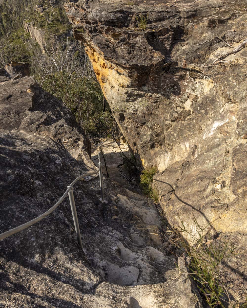

There is a metal cable here to assist with stability if needed. There is less than 100m more climbing to go to reach the junction with the Lost City Walking Track and then you are just under 250m from the Lost City Lookout and 630m from the car park.

Parking for the Lost City Track
The car parks for the Lost City are still under development, but at time of writing, the car park in the south for the walking trails described above is gravel. This is the main Lost City south car park and then there is also an overflow car park further back along the road (you will drive past it when coming to the Lost City south car park).
There are two ways of accessing the car park, the first is from Lithgow which has the least amount of driving on a gravel road, just a few kilometres and all of it 2WD accessible. Coming from further down the mountains (Katoomba etc) would see you driving for 14km of unsealed road (along the Bells Line of Road). This route is also 2WD accessible at time of writing, but is a touch bumpy in places.
The Lost City south car park is approximately 11km and a 20 minute drive from Lithgow, 50km and a 1 hour drive from Katoomba and 150km and a 2 hour 45 minute drive from Sydney.
Facilities-wise there are currently portaloos available just beyond the Lost City south car park on route to Lost City Lookout.
This post may contain affiliate links, meaning at no additional cost to you, that we will earn a small commission if you click through and decide to make a purchase. This helps towards the costs of running our website. Thanks for your support.


