

If you’re looking for a walk with beautiful views away from the crowds then head for Bald Head. It’s even more special if you head up to the ridge for sunset when the mountains and valley take on a golden glow. It does mean you have to negotiate the undulating, sometimes slightly rough track in the dark though - there are definitely easier sunset walks than this one!
Whether you go at sunset or during the day you are likely to be the only person there, which is really surprising considering how good the views are.
Here’s what to expect from the walk to Bald Head.

The Bald Head via Hat Hill Track
The stats
Distance: 7km return (inc all lookouts)
Elevation gain: 325m
Difficulty: Easy - moderate
Trailhead: Hat Hill Road, Blackheath
Summary: The Bald Head Track is not signposted, but it’s generally quite easy to follow. There was only one point on the way back in the dark that we had to look more closely for the path, but we soon found it again. There are some ups and downs throughout the walk, but no long sustained climbs.
The path is in good condition for the most part, though it is often rocky and uneven underfoot. There were only a couple of very small bits with loose soil which could be slippery towards the end of the track, but nothing hairy.
One thing to watch out for is the wind. Try to pick a calm day because if it’s a little windy at the parking area, expect it to be much more ferocious on the ridge - we definitely should have practiced what we preach as we had to brace many times on the ridge and didn’t get to sit and really take in the views and sunset like we normally would.
Starting the trail
There isn’t a specific car park for the trail, but room for several cars to pull fully off the road at these coordinates: -33.608867, 150.325755.

From the lay-by you cross over the road and follow the narrow sandy path leading into the scrub. It’s flat at first and then gently ascends, becoming a little rocky underfoot.
After 45m you’ll reach a junction and keep straight. The path climbs a little more steeply on a mix of rock slabs and rocky track.


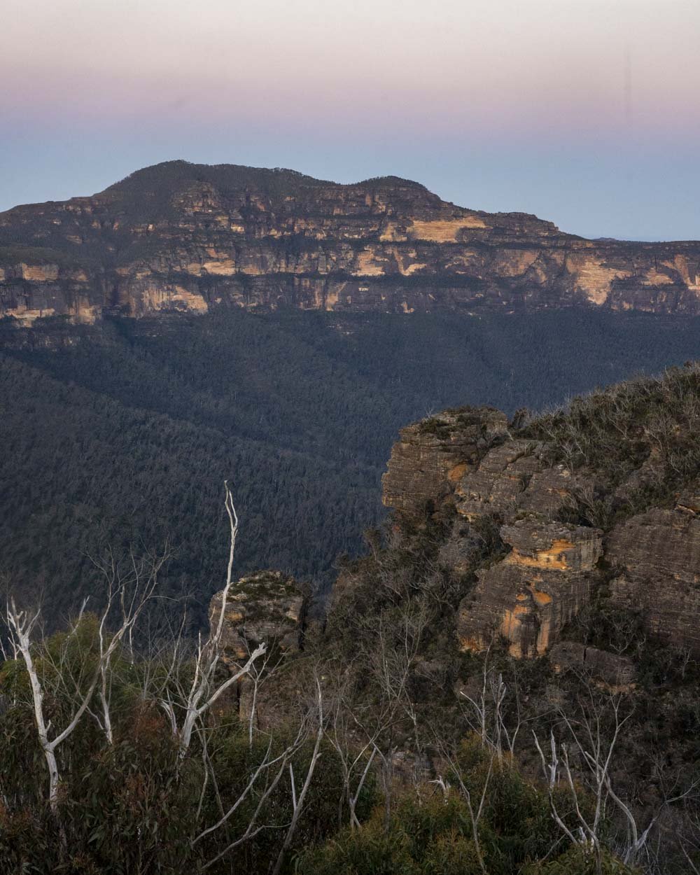
At the 220m mark the path narrows again and flattens. You’ll start to get some good views out towards the mountains and will soon arrive at an interesting rock formation, it looks a bit like a sphinx at first glance!

It’s a large pagoda with a window in the middle and it frames the distant mountains beautifully. The track continues past the rock formation, out in the open for another couple of hundred metres before you enter the bush.


Through the bush and the sunset ledge
The flat path will take you through the bush for around 100m before you emerge again and soon begin heading downhill.
The descent only lasts a couple of hundred metres before flattening, but shortly after it starts to undulate. The path can be rocky in places, but it’s not slippery and is easy to follow.

Just under 1.4km into the track you’ll reach another junction and you need to keep right here. You’ll head back into the bush and a few very short sections are overgrown, but not at foot level, so you can follow the path, you just have to watch for your arms and face!


There is one area of tree fall but it’s easy to pass around the side of it. Around 450m later (2.45km into the track) you will emerge from the bush and reach some rock ledges.
There’s plenty of room to sit and relax and the view is stunning. There are a few trees in front of part of the view, which you won’t find at the Bald Head ridge, but it’s still a wonderful vista.

As the ledge faces the sunset, if you weren’t comfortable doing the full walk back in the dark you could head up to Bald Head and then back down, aiming to reach this spot for sunset.
As it’s only a touch over 2.4km into the walk and the terrain is generally pretty good, you could likely make it back to your car comfortably in the twilight.

Continuing to the ridge
From the sunset ledge you’re only around 800m from the best view along the ridge, however, this next short section does have some rougher terrain.
You never have to scramble, but it has some steeper sections which are rocky and a couple of small bits have loose soil. It’s not difficult, but it is noticeably rougher than the path to this point.


The track continues to the right of the first ledge and leads quite steeply downhill. The path then curves right and continues descending.
There is a short section of rubbly track which is a little slippery underfoot, it’s not too bad, but requires a little more care with footing.
The path briefly flattens at the 2.7km mark and then begins heading uphill. This is the steepest bit of the whole walk, but it’s less than 300m before you reach the ridge.

Reaching Bald Head
When you reach the ridge you’re just 120m from the best viewpoint at Bald Head, however, there are glorious mountain views from the moment you step onto the ridge.

The narrow path is surrounded by low scrub so there’s nothing blocking the view. It is very exposed to the elements though so be wary if it’s really windy as there really is no escape up here!

As you continue along the worn path you’ll bear right towards the rocky outcrop, which you’ll reach just over 3.2km into the walk.
The rocky area is quite small, but there’s still enough room to sit and take in the superb views over the Grose Valley. It’s a special place to watch the sunset, especially if you opt for a calm day.

You can then continue to Bald Head itself by retracing your steps 60m back to the junction and heading right. The trail will take you along the ridge for a further 80m to a point (not really a viewpoint as such) where you can see more of the Grose Valley, though a large grassy ridge in front of the view means that it’s not quite as spectacular as the rocky outcrop. According to our map, this is Bald Head, though we definitely preferred the rocky outcrop!


Heading back
The walk returns the way you came and is of similar difficulty but for that section just below the ridge. I had to watch my step a little more here as it descends quite sharply and is loose, though it doesn’t last long.
The only other thing to note if walking back in the dark is to watch for the short overgrown bushy section, it’s not that you would lose the path, but you might take a bit of the bush to the face. We also lost the trail briefly on the rock slabs, but soon found it again when we looked more closely.
Parking for and getting to the Bald Head Track
The Bald Head Track begins on Hat Hill Road in Blackheath in the Blue Mountains National Park. There is no official car park for the trail but room for several cars to pull fully off the road at these coordinates: -33.608867, 150.325755.
There are no facilities at the parking area or anywhere else along the trail.
It’s around a 5.5km and an 8 minute drive from Blackheath and 16km and a 20 minute drive from Katoomba.
This post may contain affiliate links, meaning at no additional cost to you, that we will earn a small commission if you click through and decide to make a purchase. This helps towards the costs of running our website. Thanks for your support.


