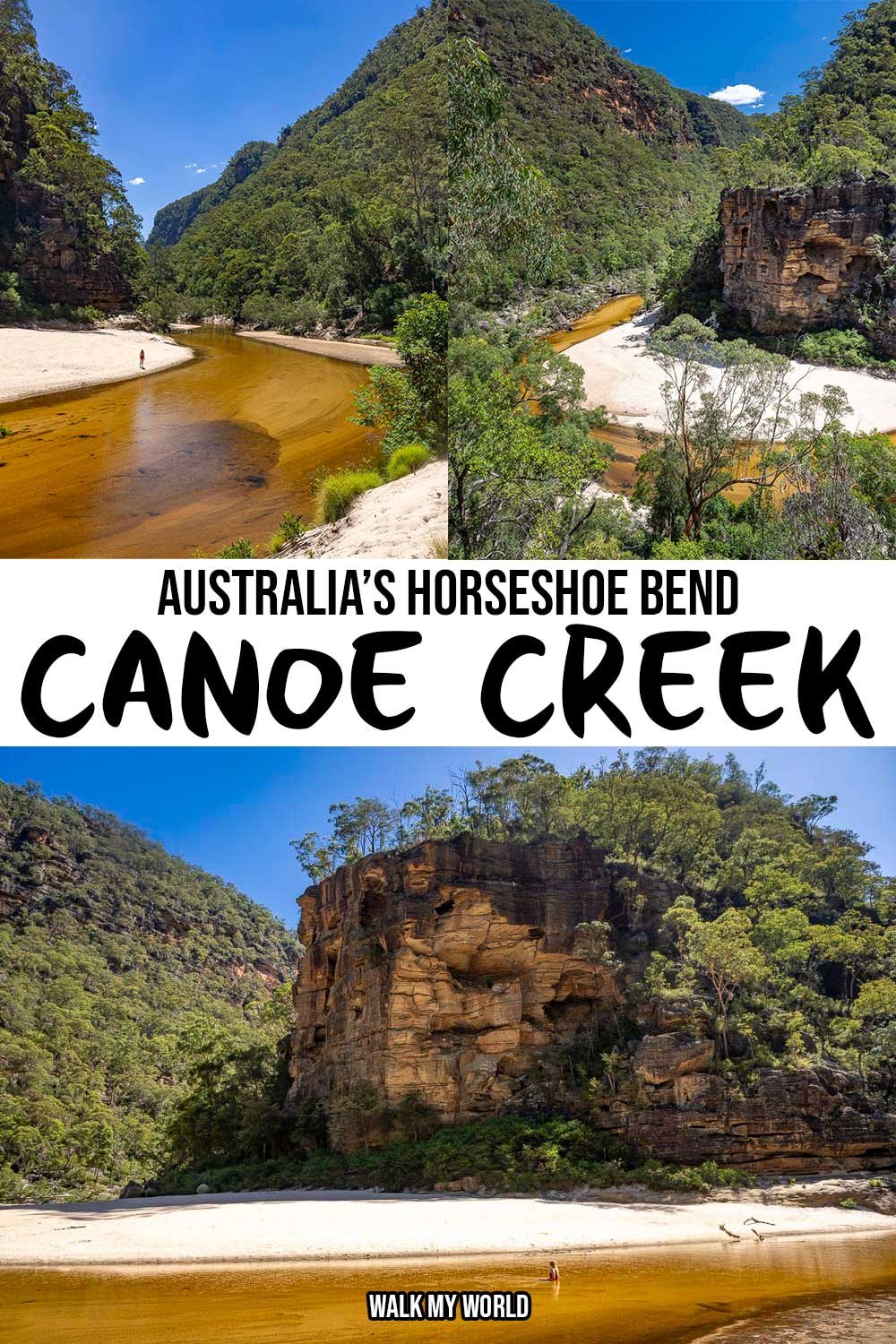
The majesty of Canoe Creek is not easily described in words; you need to feel it in person. It’s a true wilderness experience - the kind of place you feel truly alone, but it’s not daunting, it’s enchanting.
The soaring sandstone mountains are some of the most dramatic in all the Blue Mountains and the white sand beach and river are pristine. Lazing around in the crystal clear water and peering up at the towering cliff walls is nothing short of awe-inspiring.
This is a wild and beautiful place, but reaching such a treasure does not come easily. The hike is very steep and rough. But if it was easy to get to, then perhaps you would arrive to find you weren’t alone at this remote paradise, and that would be a shame indeed.
Here’s everything you need to know about the Canoe Creek Track.

The Canoe Creek Track
The stats
Distance: 7.7km return
Elevation gain: 480m
Difficulty: Hard
Trailhead: Grassy Hill Trail, Colo Heights
Summary: Just over half of the Canoe Creek Track is pretty easy and mainly flat. It’s a little overgrown in parts, but it’s not too unruly. The second half is rough and very steep as you descend to the creek and river.
Much of the track has a fine covering of loose dirt which makes it a bit slippery - though there are a lot of trees and bushes to use for extra stability.
There are some short eroded sections, which are very narrow and also several scrambles and rocky sections. I personally much preferred climbing up the track than going down it, as the terrain felt more stable.
We were 30 minutes quicker going up than down, though Joe would probably have been about the same both ways, I am a very slow descender!
This area is remote and there is no phone signal, so it would be wise to carry a PLB and have an offline map with you. It’s not the sort of place you would bump into someone for help if it were required. The path is relatively straightforward to follow, though sometimes the cairns can be contradictory. I will note as best I can the route we took.
The easy beginning
From the parking area (full details below) you follow the path on the left and will immediately see the locked gate in front of a fire trail.
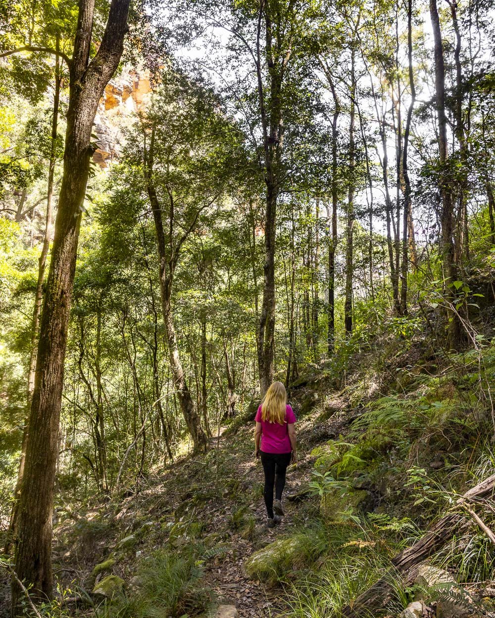
This first part of the walk follows an old fire trail, but it’s now somewhat overgrown.


Compared to the majority of off track walks we’ve done lately, it was minimal and we found it to be a lot more pleasant than we were expecting.
The bush is very pretty and there was the near constant chime of Bellbirds. There are a couple of washed out sections where you need to negotiate some gullies, but footing is good.

There are a few trees down over the path, but nothing that was difficult to duck under or over. This first part of the walk is either a gentle downhill or flat.
Around 1.3km into the track it gets a little more overgrown, but it gets better again a few hundred metres later. It’s approximately 1.9km into the trail when you reach the more significant eroded gullies and treefall, but as mentioned, it’s all fairly easy going.


Roughly 2.2km into the walk you need to take the path heading downhill on the left, there are a few logs placed across the path on the right to encourage you to take that left track.

The bush track
The first part of this narrower bush track is a gentle descent and the path is good, but there are some scratchy bushes which encroach at times. The more noticeable descent begins 250m later, or 2.45km into the track. There’s a short steep section, but with good footing, followed by a 100m stretch of flat track before it really ramps up!

The next 100 or so metres are really steep and the first few steps are loose and near a drop. It’s right beside a large rock, with a lovely view over the trees and tops of the cliffs.
If you’ve read any other of our guides to steep walks, you probably already know that steep loose terrain is my nemesis.

I saw this section and honestly nearly turned back! If you’re surefooted and confident you may not even give it a second glance, but to me, it was a few steps of horror. Well, I won’t lie, there weren’t any steps involved.
I opted for the bum shuffle approach. Happily, this was the worst bit of the track for me and I was relieved no other sections were as steep and loose; they were steep (though not as steep), but not loose.


The next section heads downhill on a worn dirt track with intermittent rocky sections. I made full use of the surrounding trees and bushes for extra stability!
After roughly another 250m you enter a shady and boulder strewn part of the forest (2.9km into the walk).

The scrambles
There are a few narrow eroded sections in the forest, but usually just a few steps and usually beside trees or rocks you can grab if needed.
Around 100m into the forest section, or 3km into the walk, the trail curves right and there’s a yellow ribbon tied to the tree to reassure you you’re on the right track.


This is also one of the short eroded sections. The path will then briefly flatten and you can take a good look around at the gorgeous forest.
Around 150m from the ribbon you’ll come to an overhang and you need to climb down to the ‘track’ below.

It’s easiest to slide off it, but there is a foothold/ledge halfway down if needed. This is slightly trickier in reverse as you need a good solid leg stretch to get back up.
The cliff wall on the left has a good handhold to help. You then have a short flattish section and will come to a large rock which you can just jump/slide off, it’s not tall.
You’ll now be in a very spectacular part of the forest, with high rock walls and oodles of knotted hanging vines. This also marks the start of two possible routes for the next part of the descent.

We used both routes and one is much harder than the other! Our preferred route was to cross the little open bit of forest towards the right, but don’t follow the cairn on the far right.
This leads to a steep and very loose gully, which is far trickier to descend.

Look for the cairns leading left and follow the easy rocky path, which is not overly steep and it’s nice and stable. You’re basically climbing down a few rocks as opposed to a gully where the earth moves beneath your feet!
Roughly 70m from the hanging vines area (3.3km into the walk) you’ll get your first glimpse of Canoe Creek. If there has been a lot of rain there are some inviting pools and even a small waterfall along the creek, but for us it was quite dry and there was no flowing water, so we didn’t explore too much.

Reaching the Colo River
The next part of the walk bears right and is very narrow in places, some small bits are eroded. There has also been at least one slip, leaving a bit of debris to manoeuvre around. Aside from the eroded bits, this part of the track is pretty good and never too steep.
After 300m (3.6km into the walk) you will come to the most magnificent view of the whole trail, a few seconds detour to the right. This is the classic view where you can see what we came to think of as ‘Australia’s Horseshoe Bend’.
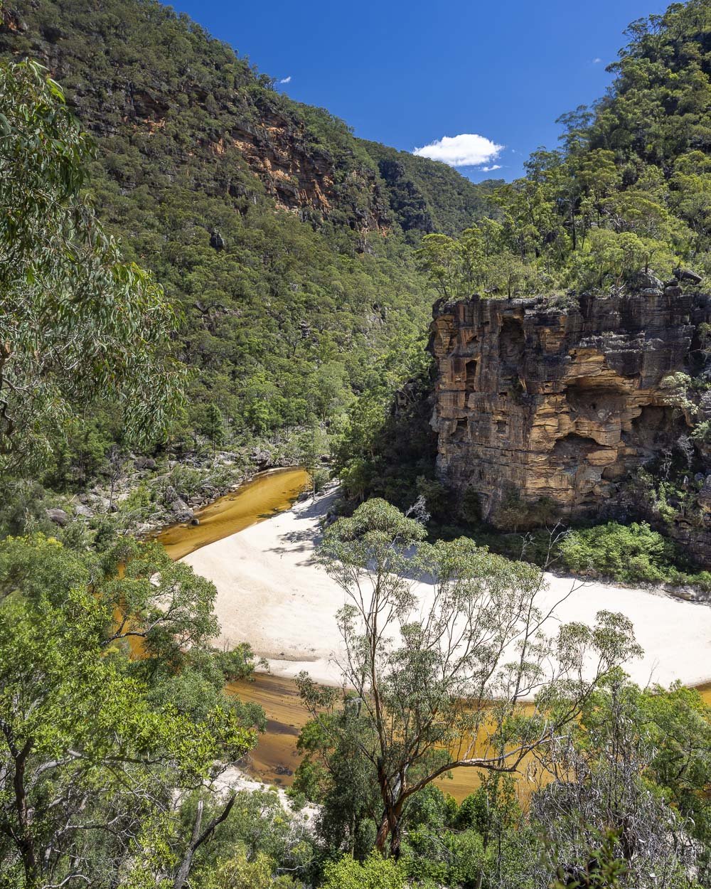

It really is sensational, with the mountains, river bend and a little bush in the foreground. There’s also a large rock where you can sit and admire it from.
The track continues a few paces back, and to the right (the left if coming from the trail before the lookout). It’s inbetween two large rocks and fairly obvious.
You’ll keep heading downhill, but it’s much easier trail conditions, and for me, much more enjoyable.

The scrambly bits are all down rocks or rock chutes, which are grippy and don’t require too much thought. Then the very last section is across the sand and to the flat area behind the bend.

The Colo River
The view from the beach is sublime, but it’s from the water that you truly feel surrounded by mountains. It’s a majestic scene, with some of the steepest, most dramatic mountains in NSW. You feel tiny and insignificant in the best possible way.

The water is crystal clear and as such appears golden, as you can see the sandy bottom anywhere that it’s shallow.
There are a couple of very short deeper pockets of water, but no part of the main bend offered a proper swimming opportunity.
It’s more for lazing, or better still, floating on a lilo! There is a pretty strong current, or there was on our visit, so if you did have a lilo, you’d get a bit of a workout floating and then wading back to the beginning before going again.

The water is relatively warm and the sand positively scorching in summer, so it was a delightful place for a dip. I’d have loved to have had a proper swim, but it was hard to leave this magical spot, so I made do with relaxing in the shallows.

We were only visiting for the day, so we didn’t explore the river, though I know it’s spectacular and warrants more time to get to know. You can even do lilo trips exiting at Bob Turners Track (another amazing hike).
People do camp in this area, which would definitely give you a lot more time to see more of what the Colo River has to offer. Please remember to carry everything out with you.

Keep them wild
Please remember to take all rubbish with you and keep these places wild and pristine - as with anywhere in the outdoors. It’s important to leave them exactly as you found them so they will remain beautiful for generations to come.
Litter tends to breed litter, so if you do spot any and are able to pick it up and dispose of it outside the national park, it will go a long way to keeping the area clean.
The climb out
I thought the climb out would be worse than it was! It took us a little under two hours moving at a leisurely pace and stopping for a nice break on that big rock by the start of the steep descent. A couple of the scrambles required a little more thought on the way back up, but generally speaking, I found it much easier. It would be harder going with all your camping gear though!

Just remember to try and follow the same route back at the point I mentioned there were two options and one was worse than the other. This is roughly 450m from the beach.
Though it is easier to ascend that steep eroded gully than descend it and there are sturdy tree roots for handholds, it’s still better to go the more stable way.
The Canoe Creek Access Road
Access to the Canoe Creek Track is via the Grassy Hill Fire Trail in Wollemi National Park, near Colo Heights. It’s around 1 hour from Bilpin or 1.5 hours from Sydney - click here to find the turn from Putty Road on Google Maps.
Once you turn off the main road the next 8.7km are unsealed. It’s a fire trail, but rough in places and a couple of spots had some deepish ruts which required careful manoeuvring. There were some puddles, which I imagine become larger and muddier after big rain, making the road more difficult.
There are some short but steepish sections which are rocky. We would personally only drive this road in its current state in a 4WD or AWD, but I have heard people do manage in a 2WD, though I think you need a little clearance and we would never attempt it. We are not confident off road drivers and therefore always err on the side of caution.
There’s a decent amount of parking space by the trailhead, so you shouldn’t have any trouble parking, it’s at these coordinates: -33.2710420, 150.5912188 (or you can click here to find it on Google Maps).
There is also more parking opportunities 500m further up the road, but I can’t imagine you would ever have to use it unless there was a big bushwalking group visiting on the same day!
There are no toilets or any other facilities at the trailhead.
This post may contain affiliate links, meaning at no additional cost to you, that we will earn a small commission if you click through and decide to make a purchase. This helps towards the costs of running our website. Thanks for your support.