

It boggles my mind that a walk as fabulous as the Big Hole and Marble Arch Track is a relative unknown. The Big Hole is a giant sinkhole which is cool to see, but the real jewel in the crown is the marble cave and gorge beyond.
The mouth of the cavern is dripping in moss and a huge boulder sits wedged on top, entering it feels like you’re stepping into the pages of a fantasy novel.
The cave has some great formations and it’s a lot of fun to explore - we would have been thrilled with the cave alone, but this is the track that just keeps on giving! We walked through the cavern and came out into an incredible limestone gorge that we had no idea was there. Heading through the narrow gorge brings you to a hidden waterfall and another small cave.
To say our expectations for this hike were exceeded seems an understatement.
The location of this track is quite remote, but it’s easily day trippable from Canberra, Goulburn, or Batemans Bay and if you’re lucky enough to be in any of those areas, you definitely need to put it on your list.

The Big Hole and Marble Arch Track
The stats
Distance: 12.7km return (including exploring the cave and gorge)
Elevation gain: 400m
Difficulty: Easy - moderate
Trailhead: Berlang Campground
Summary: The walk to the Big Hole and Marble Arch begins with an unbridged crossing of the Shoalhaven River. During times of normal flow the water is well below knee height, but you would not want to attempt it after heavy rain.
The track to both the Big Hole and Marble Arch does have a few hills to climb, but there’s plenty of flat track inbetween. The elevation gain is spread out over such a distance that it really didn’t feel significant, so we were very surprised to see the stats and I still feel it might have been our watch over-reading it!
The trail condition is generally very good, though the final descent to the cave is a touch rougher.
Walking through the cave involves some rock hopping and if you continue into the gorge, some sections are a little slippery due to water and mud on the gorge floor.
Starting the trail: crossing the Shoalhaven River
The first 150m of the track from the car park is flat and leisurely before you arrive at the Shoalhaven River. As mentioned, the water levels are usually low, for us it was below knee height and the crossing was very easy.

There are small stones on the river bottom but with boots on, it was straightforward and not in the least bit slippery. If you want to keep dry boots, it’s going to be a bit more uncomfortable underfoot.

Incidentally, if you are hiking on a warm day and fancy a dip, you can make a short detour to a swimmable section of the river. We made the detour on the way out but I decided I would rather swim on the way back.
Due to the fact we had no idea the cave was going to be so amazing, we ended up running out of time, so I can’t tell you exactly what it’s like unfortunately. However, I can tell you how to get there.

Before crossing the river you want to begin heading downstream (right when you get to the water). There are worn social trails close to the water and a little further back in the bush.
Sections can be a tiny bit overgrown, but it’s still easy.

If you head downstream for 200m you will come to a small stony area beside a deeper part of the river. How deep I can’t tell you, but it certainly looked swimmable to me!
The setting is pretty, with lots of gum trees lining both sides of the water.

To the Big Hole
Back at the main trail and you’ll cross the river and then begin heading gently uphill. There are a few slightly steeper sections, but most of the way to the Big Hole is so gently uphill that it almost feels flat.

You’ll head through the bush, which is dotted with termite mounds and then there is a short section around 1.6km in when you get some lovely mountain views.
I really liked this section, it gave me definite Snowy Mountain vibes.

You will then re-enter the forest and the final 300m to the viewing platform is pretty much flat. You’ll reach it around 2km after leaving the car park.
The viewing area is pretty swanky now, with a seating area and railed lookout allowing you to peer right down into the abyss.

The depression is very, very deep (110m) and I imagine that looking down into it before there were railings would have given you a good stomach lurch.
Normally I’m not one to appreciate railings, I much prefer a natural view, but I do think in this case it allows you to get a really good look down in a way I don’t think I would dare if the rails weren’t there.

It’s thought that the sinkhole is the result of sandstone collapsing into the limestone cavern below.
Through the bush towards Marble Arch
The next part of the walk is all through the bush and the excellent trail conditions make it very relaxing. It reminded me of why I fell in love with the Aussie bush in the first place, with an abundance of wildlife and only the sounds of the birds breaking the silence.

On the subject of wildlife, the next few kilometres were alive with Red-necked wallabies and kangaroos who would go bounding through the bush when they heard us coming. We were even lucky enough to spot an echidna, though sadly it was too shy for a good photo.

The first 150m of the track from the Big Hole is a steepish descent and then it gets much more gentle. The vast majority of this section through the bush is flat and the dirt path is well maintained and easy to follow.
It’s intermittently marked with small wooden posts and the only time you might possibly not spot the path is around 700m from the Big Hole, when it crosses a fire trail and heads back into the bush on the other side.


Roughly 3km from the Big Hole you head onto what seems like a disused fire trail and long grass makes it feel a little overgrown.
Just 300m later you’ll see the main information board for Marble Arch, this is around 5.3km into the walk.

Descending to Marble Arch
At the point you see the main signpost (which is sadly so faded you can’t learn much about the cavern) you are now just 600m from the cave entrance.
The path is to the right of the sign and will immediately begin heading downhill. You’ll get some wonderful peeks out to the mountains along this section and as you descend the forest becomes more lush. The path down to the cave is a mix of dirt track and stairs.


Some of the stairs are a little worse for wear, but it’s still not difficult to descend. Around 350m into the descent you’ll see some limestone rock and around 100m later you’ll reach a small creek. At this point you head right.


It’s almost dry and can be easily stepped over. From here there is no set track and things get more rustic. You’ll walk across a little bit of rocky terrain and over a fallen tree (easy to climb over).
A few large ferns give it a wild feel and after 50m you’ll see the cave entrance.

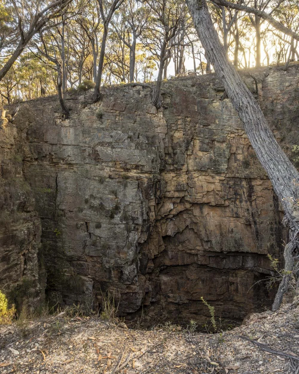
Exploring Marble Arch
The entrance to the cavern is incredible. The limestone walls on either side are dripping in moss and a large boulder sits wedged above the entryway.
After stepping inside, I was taken aback by how big the cave was. The floor is littered with marble, some pieces are the size of a small car and some are tiny enough to easily walk over.

I’m used to caves you can explore without a guide being almost free of formations, but Marble Arch has some good ones, including flowstone (remember never to touch any formations as it causes irrepairable damage).
Whilst there is a lot of light inside the main chamber, certain sections still require a torch. It’s easy to move through the cave, but take care on the uneven ground, which due to the covering of small stones, can be a touch slippery in places.

Though light does penetrate much of the cave, it still has a dark and mysterious feel and looking back at the entrance from inside the cavern is just as good as looking in from the outside.

As you exit the cave, there is a short section with a lower ceiling to get through, but you only have to crouch a little and it’s just a few steps.


Exploring the limestone gorge and hidden waterfall
When you exit the cave you’ll come to a rocky area with some beautiful tree ferns. We didn’t realise there would be anything much to see, but went for a poke around nonetheless. And as it turns out there is plenty to explore!


You can pass around the back of the tree fern and it will lead you down into a rocky gorge. The limestone walls are high and dramatic.
The gorge runs for around 170m and if you don’t mind getting wet boots, you can explore the full length of it.

It’s rocky at first and then you will enter a narrower part of the gorge and this is where you will encounter very shallow water.


It’s mostly below ankle height, but a few pools are above the ankle, though not by much. Some short sections of the gorge floor are slippery due to water and mud, but it’s not too bad if you take it carefully.

Just before the end of the gorge, 160m from the beginning, you will come to a small waterfall.
It’s very pretty and also quite fascinating to see it flow from inside the gorge wall. It was the cherry on top of an already fabulous experience.


Just before the waterfall, on the right, you’ll see a small cave which you can easily climb into. Just watch for the damp patch which is slippery.
It’s only tiny, more of a passageway than a cave, but it has some cool formations and a view over the gorge.


It was the perfect end to a fun adventure and one of our new favourite walks in NSW!
Getting to the Big Hole and Marble Arch Track
The trail is located in Deua National Park, NSW and the last 700m of the road to the car park is unsealed, but suitable for any car at time of writing. You can see the exact location here. Currently Google maps overestimates the time needed to make the journey by around 15 minutes as it wants to take you on a different road right at the end of the journey.
The trailhead is around 1.5 hours from Canberra and Goulburn and around one hour 15 minutes from Batemans Bay.
There is a campground beside the trailhead and a long drop toilet nearby.
This post may contain affiliate links, meaning at no additional cost to you, that we will earn a small commission if you click through and decide to make a purchase. This helps towards the costs of running our website. Thanks for your support.


