

Deep in the Grose Valley, down an unmarked track, you’ll find the jungly ruins of the old Faulconbridge Timber Mill. They are slowly being reclaimed by the surrounding forest and the result is very atmospheric. Their location deep in the valley feels so unlikely and scouting around for the rusting relics is something of a treasure hunt.
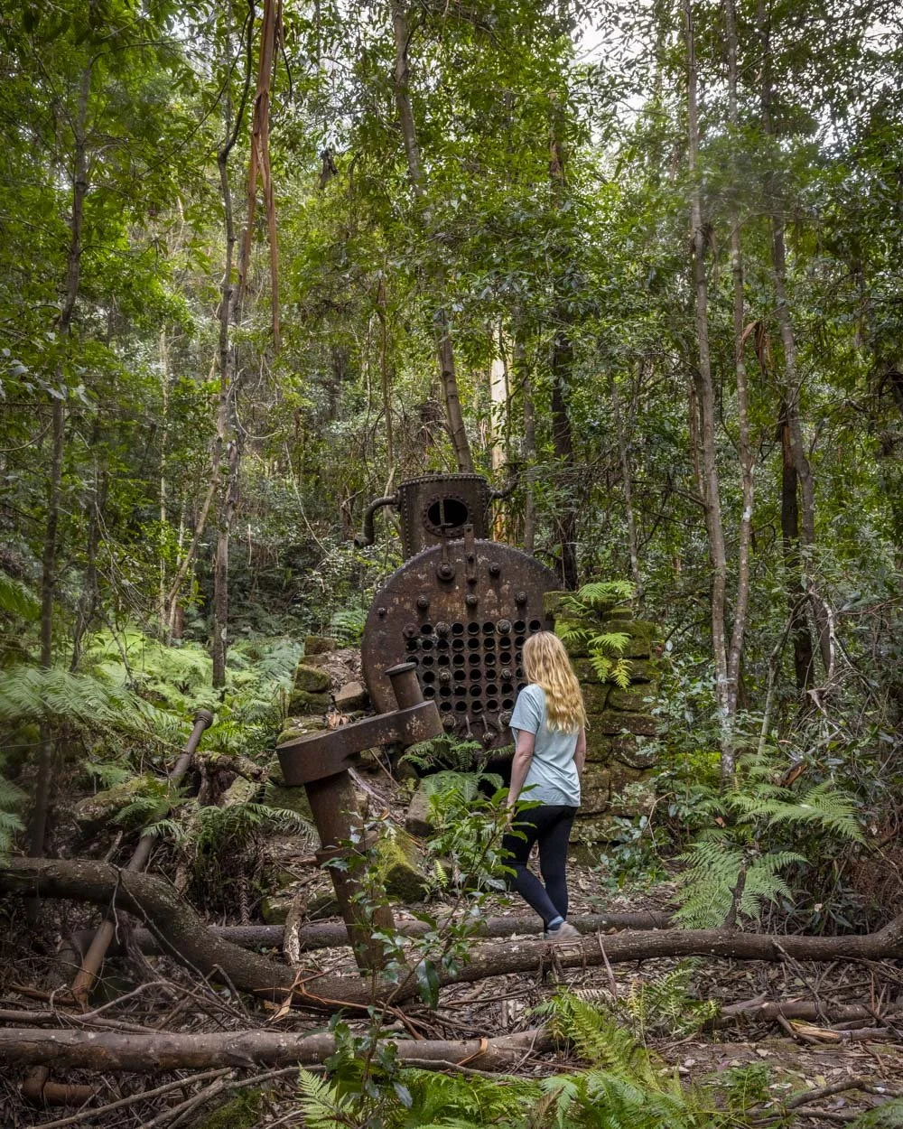
The most impressive part of the mill that remains is the old steam boiler, but poke around in the ferns and nearby creek and you’ll also discover bits of railway line, wheels, steel cables and more.
Though part of the walk is off track, it’s actually a fairly easy hike, with the scratchy scrub we normally encounter off track being noticeably absent. There’s a reasonably steep climb into and out of the valley, but it’s on a decent trail, which is not slippery when dry.
Here’s how to find the remains of the Faulconbridge Timber Mill.

The Faulconbridge Timber Mill Track
The stats
Distance: 3.7km return, including a bit of exploring
Elevation gain: 194m
Difficulty: Easy - moderate
Trailhead: Highland Road, Faulconbridge
Summary: The first 1.3km of the walk is on a pretty good track, most of which is wide fire trail. From here there is one short but steep descent on a rocky trail, but when dry, it’s not slippery and you walk down large rocks, not small loose stones.
The final part of the hike doesn’t have a path and involves one easy creek crossing (easy when the flow of the creek is not too high).
There is a small amount of rock hopping to reach the mill remains.
When wet, or after heavy rain, this walk would be much harder as the creek will be up and the area surrounding it, particularly the rocks, could become very slippery. You may also encounter leeches after rain.

Starting the trail: along the fire trail and into the bush
From the parking area (the end of Highland Road in Faulconbridge) the walk heads along the Highland Road Fire Trail. The first 100m are on a wide fire trail before the path will narrow. There’s a short section on smooth rock slabs before you begin heading along a flat sandy path through the bush.

At the 400m mark there is a brief uphill section before the path flattens again. You’ll begin descending at the 700m mark, but the path is still good, there is some uneven terrain, but it’s not slippery.
After 930m (from the parking area) the path becomes rocky and it’s a little steeper. It’s still quite straightforward, but you do have to watch your footing. The track will flatten again 300m later.


It gets steeper
It’s a brief reprieve though as 60m later you’ll reach the steepest part of the whole walk. It’s only 50m, but it’s significantly steeper. You descend on large rocks rather than loose stones, so it’s not too difficult and I wouldn’t really call it a scramble. It’s much like the final descent into the Duck Hole or Glenbrook Beach.

I can imagine it would feel different if the rock was wet though. The view from the top of the rocky descent is one of my favourites along the trail as you can see the densely forested cliff looming steeply ahead of you.

At the end of the rocky section the gradient becomes more shallow. The dirt path is narrow, but for the most part, gentle. We were walking in early spring and the wildflowers along this section were glorious.


Roughly 50m into the dirt track there is a tree down over the path, but it’s easy enough to climb over. There are another couple of fallen trees a little further along the track too, but these are skinnier and therefore easy to manoeuvre around.

Roughly a couple of hundred metres into the gentle descent the path will steepen again, but it’s still much less steep than the rocky section. It gets noticeably greener and damper, with lots of gorgeous ferns lining the path.

Reaching the creek
Just over 1.6km from the parking area you’ll reach the creek. You need to continue heading straight.
There is some debris around which necessitates a bit of rock hopping and clambering, though when you see the overhang on the right there is a clearer way to continue.
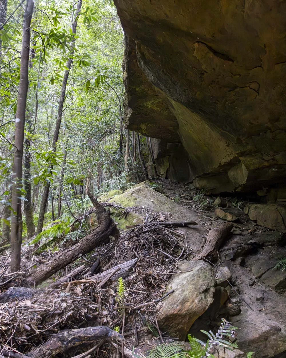
Roughly 80m after reaching the creek section you need to come down from the overhang (there is a little worn path) and just beyond this you can easily cross the creek. You’ll see a large rock and be able to hop across with dry feet as long as the creek isn’t running high.

Just to the left of this spot, in the creek itself, is a wheel. You can bushbash a little to get closer to it, though there is another set of wheels closer to the ‘path’ further along.

Finding the old Timber Mill relics
When you cross the creek you’ll climb up the bank on the other side and reach a series of boulders. Though you still need to tread carefully, they were not slippery when dry.
Just off to the right, at the creek junction, you’ll see a set of wheels on their axis inside the water.

To find the steam boiler, follow the boulders upstream towards these coordinates: -33.6880395, 150.5208122 You’ll see two sets (possibly more as we may have missed some) of old steel cable on the way.
The rock hopping is easy enough when dry. There’s one more fallen tree to climb over and then there’s a dirt path alongside the creek. The steam boiler is roughly 70m beyond the steel cable and with the coordinates you can’t miss it!


Faulconbridge Timber Mill steam boiler site
The steam boiler is the most impressive of the remaining relics at the old timber mill site. It’s surrounded by tall gum trees, ferns and a bit of mossy wall, which gives it a jungly feel.


If you like photography I would say it’s best visited on a cloudy day when you’ll get even light, and the lack of sun makes it feel more atmospheric.
There are other relics either side of the boiler, with most being behind it, including part of the railway line and a drive shaft.


Some of the remains are scattered in quite dense ferns, so you do have to poke around a bit. We continued for around 50m past the boiler to the creek. The path appeared to continue, but we were happy with what we’d already seen.
In terms of the mill’s history: it was built in 1913 by Henry Joyce and only in operation for 14 years.
The mill was used to cut railway sleepers which were then hauled up the cable railway, ready to be transported to the train station by horse and cart. You can read a more detailed account of the site’s history here.
The walk back
After exploring the site the easiest route out is the way you came. There are some worn paths you can follow around the initial creek crossing, with a few nice overhangs if you want to explore a little more. The walk back has a couple of steep sections, but also plenty of flat track.
If you happen to be walking out close to sunset, there’s a rocky outcrop 200m before the parking area, just off the right side of the fire trail which has a great sunset view.

It’s only a few seconds off the path and there’s plenty of room to sit and watch the sun set over the dense forest. It was just by chance that we were finishing up at sunset but it made for a beautiful end to the walk - although it would have been even better if there wasn’t a controlled burn happening in the distance!
Getting to the trailhead for the Faulconbridge Timber Mill walk
There is no official car park for the walk, but plenty of free parking on Highland Street, just beside the trailhead.
It’s around 4km and a 5 minute drive from Faulconbridge, 26km and a 25 minute drive from Katoomba and a 1 hour drive from Sydney.
This post may contain affiliate links, meaning at no additional cost to you, that we will earn a small commission if you click through and decide to make a purchase. This helps towards the costs of running our website. Thanks for your support.


